
On the Sangamon River, Ill's (ca. 1900-05)
Image from the Detroit Publishing Company in the Library of Congress' collection.

Aerial photo taken just west of Allerton Park July 29, 1940 showing a segment of the Sangamon
From 1937-1947 Illinois Historical Aerial Photography, in the Illinois Geospatial Clearinghouse.

Aerial photograph taken July 5, 1940, showing Elsworth Illinois and the origin of the Sangamon to the east.
From 1937-1947 Illinois Historical Aerial Photography, in the Illinois Geospatial Clearinghouse.

Aerial photograph at the confluence of the Sangamon and Illinois Rivers, taken on on July 9, 1939
From 1937-1947 Illinois Historical Aerial Photography, in the Illinois Geospatial Data Clearinghouse
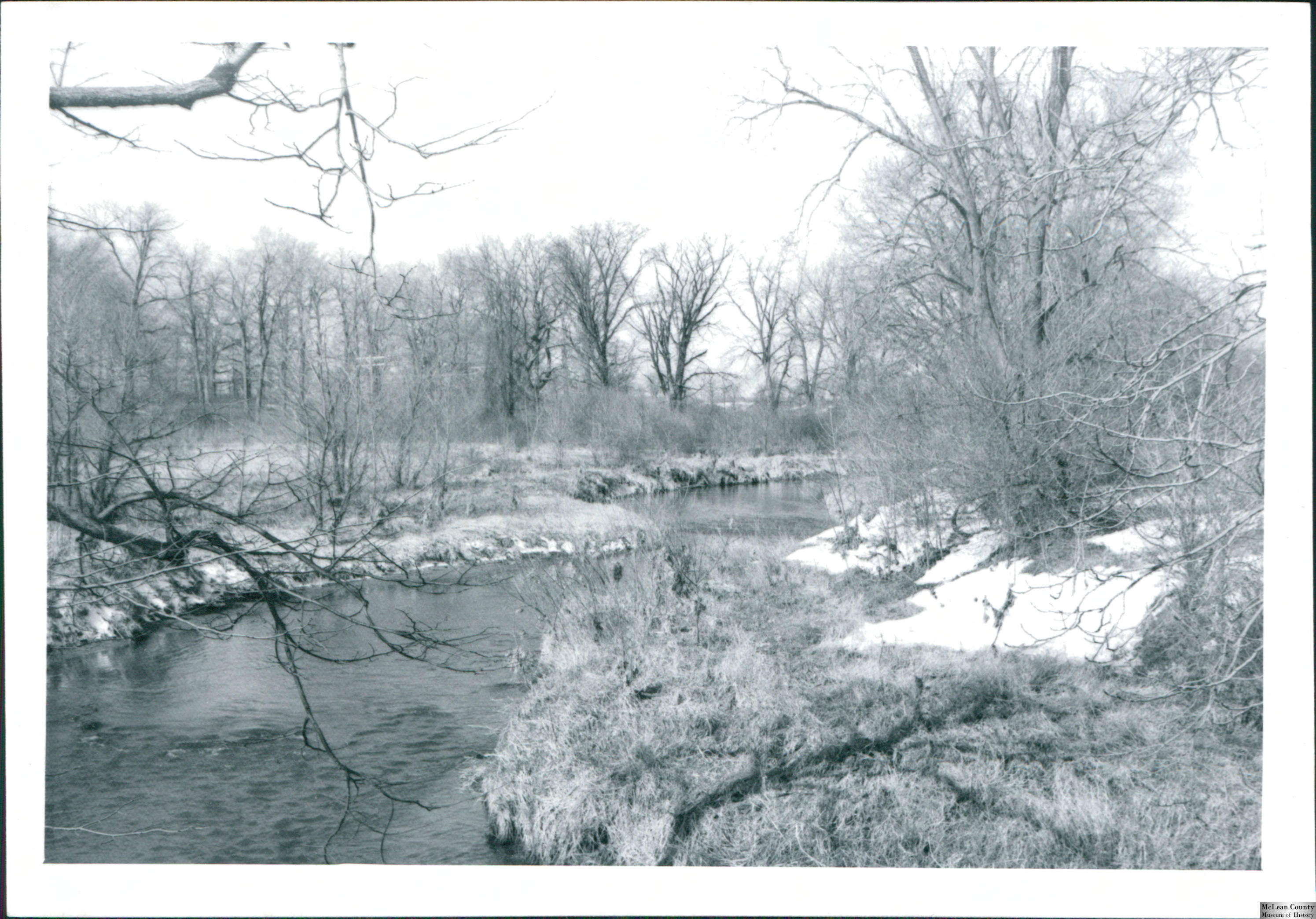
Sangamon River in eastern McLean County, 1975
From the Michael Sublett Collection of the McLean County Museum of History, available via the Illinois Digital Archives.
About the Sangamon River
The Sangamon River basin is the largest of the Illinois River tributaries and drains 5419 square miles, with headwaters in McLean County near Ellsworth, flowing east into Champaign County and then southwest (Upper Sangamon River Area Assessment vol. 2, 1999). The Sangamon flows ~248 miles from Ellsworth to the Illinois River at Beardstown (Lower Sangamon River Area Assessment, vol. 2, 2000). The basin includes portions of Cass, Champaign, Christian, DeWitt, Ford, Logan, Macon, Macoupin, Mason, McLean, Menard, Montgomery, Morgan, Moultrie, Piatt, Sangamon, Shelby, and Tazewell Counties (Illinois State Planning Commission, 1938). The majority of the basin is in the Grand Prairie Natural Division (Page et al, 1992). The Sangamon was historically dammed near Decatur, beginning in 1878 with a wooden structure, replaced by concrete and with the addition of hydraulic gates controlling levels of Lake Decatur which provides the city's water supply (Upper Sangamon River Area Assessment, vol. 2, 1999). The Oakley Dam project initially proposed in the 1940s for flood control, water supply, and recreation would have inundated Allerton Park and due to strenuous opposition was not built (Marlin, 1971).
Sangamon River: select documents in chronological order
-
Surface water supply of Illinois, central and southern portions, 1908-1910 by
Publication Date: 1911The Sangamon River is Covered on pp. 128-170.
-
Investigation of the destruction of fish in Sangamon River below Springfield

by Paul Hansen and Ralph HilscherPublication date: 2016
pp. 251-255 in ISWS Bulletin no. 13 (Chemical and biological survey of the waters of Illinois: Report for year ending December 31, 1915)
-
Quality of water in Illinois streams [with discussion]
byPublication Date: 1919Paper presented at the Illinois Section, American Water Works Association March 25-26, 2019 Urbana, IL, discusses pollution of Illinois streams using the Sangamon River as an example of a "seriously polluted stream."
-
The quality of water in the Sangamon River by Minna Ernestine Jewell
 Publication Date: 1920
pp. 230-246 in ISWS Bulletin no. 16, Chemical and Biological Survey of the Waters of Illinois: Report for years 1918 and 1919.
-
Is the Sangamon River Navigable?
byPublication Date: 1920from the Journal of the Illinois State Historical Society.
Relates an anecdote about Lincoln claiming steamboat navigation was possible on the Sangamon, and his demonstration using a model boat in a trough set up to mimic the Sangamon's sandbars and shoals, using air pumps to float the boat over the obstructions. -
The Fishes of Champaign County: A study of the Distribution and Abundance of Fishes in Small Streams
byPublication Date: 1930INHS Bulletin vol. 19 Article 1.
The Sangamon River is one of six Champaign County streams described and sampled. -
The Plankton of the Sangamon River in the Summer of 1929 byPublication Date: 1930
-
Report on the Sangamon River Basin in Illinois by
Publication Date: 1938 -
Remedial Works at the Mouth of the Sangamon River : Environmental Statement
byPublication Date: 1970Report on the impact of a proposed action to remediate a Federal Flood Control Project in 1949 which had diverted the mouth of the Sangamon. -
Vascular plants of the Sangamon River basin; annotated checklist and ecological summary by
Publication Date: 1974University of Illinois at Urbana-Champaign, College of Agriculture, Agricultural Experiment Station Bulletin, no. 746. -
Water quality management basin plan, phase I : Sangamon River Basin. byPublication Date: 1976
-
 Hydrometeorology of Heavy Rainstorms in Selected Illinois Basins
by
Publication Date: 1981ISWS Report of Investigation no. 96
Hydrometeorology of Heavy Rainstorms in Selected Illinois Basins
by
Publication Date: 1981ISWS Report of Investigation no. 96
The Sangamon Basin is covered on pp. 45-52. -
A Summary of Information Related to the Comprehensive Management of Groundwater and Surface Water Resources in the Sangamon River Basin, Illinois byPublication Date: 1982ISWS Contract Report no. 299
-
A survey of the freshwater mussels (Bivalvia: Unionidae) of the Sangamon River Basin, Illinois by
Publication Date: 1991Illinois Natural History Survey Biological Note no. 137 -
Biologically Significant Illinois Streams : An Evaluation of the Streams of Illinois Based on Aquatic Biodiversity
byPublication Date: 1992The Sangamon is covered on pp. 203-230. -
Biologically Significant Illinois Streams : An Evaluation of the Streams of Illinois Based on Aquatic Biodiversity
byPublication Date: 1992The Sangamon River is covered on pp. 202-229. -
 Upper Sangamon River Area Assessment
Publication Date: 1999
Upper Sangamon River Area Assessment
Publication Date: 1999 -
 Lower Sangamon River Area Assessment
Publication Date: 2000
Lower Sangamon River Area Assessment
Publication Date: 2000 -
The Heart of the Sangamon : An Inventory of the Region's Resources by
Publication Date: 2000 -
The Lower Sangamon River Valley : An Inventory of the Region's Resources by
Publication Date: 2003
Oakley Dam and Allerton Park
-
Alternatives for the Oakley Reservoir Porject : a report
byPublication Date: 1968
-
Oakley Dam in the Audubon Newsletter, 1968-1971News and editorials published in the Illinois Audubon Society's newsletter as the fight over the reservoir pool depth played out. Each mention of the dam within the volume is indexed.
-
The Oakley Project: A Controversy in Land Use by
Publication Date: 1970pp. 33-39 in Land-use problems in Illinois : papers from a symposium at the meeting of the American association for the advancement of science, 137th, Chicago, December 26-31, 1970 -
Battle for the Sangamon: the Struggle to Save Allerton Park byPublication Date: 1971Documents the work of the COAP to protect Allerton Park from destruction by the development of the Oakley Dam and reservoir project. This work is in copyright and has not been digitized, but there are multiple print copies in the University Library.
-
Three-dimensional seepage model study, Oakley Dam, Sangamon River, Illinois byPublication Date: 1972Seepage model studies were conducted for the proposed Oakley damsite using a three-dimensional electrical analogy seepage model. Test results indicated that uplift pressures beneath the spillway will vary from 59 percent of the net head at the upstream edge of the structure to 49 percent at the downstream edge. Test results also indicated that piezometric heads at the downstream toe of the dam even with a 1000-ft upstream impervious blanket will be higher than can be safely tolerated. Computed total seepage with the reservoir at flood control pool varied from 2780 gpm (6.2 cfs) to 3290 gpm (7.3 cfs). It is recommended that other seepage control measures such as relief wells and a positive cutoff be investigated.