
Aerial photograph from July 1939 showing a segment of the Fox River flowing into Grass Lake in northwestern Lake County, Illinois
From 1937-1947 llinois Historical Aerial Photographs in the Illinois Geospatial Data Clearinghouse
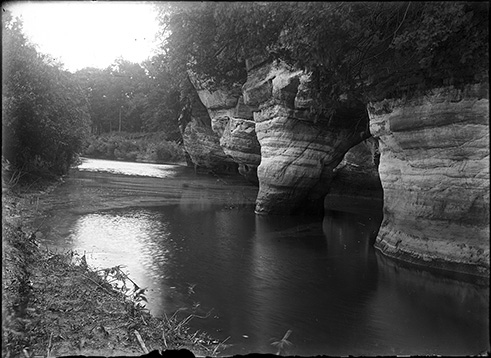
Sandstone along Fox River
From the Chicago Academy of Sciences / Peggy Notebaert Nature Museum; Audiovisual Collection. Date unknown

Fox River near Geneva, Ill. 1880
from Library of Congress Prints and Photographs Division

Fox River near Batavia, Ill. 1880
from Library of Congress Prints and Photographs Division

Fox River above dam, Elgin, Ill. 1910
from Library of Congress Prints and Photographs Division

Elgin past and present : 1835-1930
Animated historical map by: Robert Brightman and Robert Gatechair. Produced by the Elgin Branch of American Association of University Women.

Aerial photograph from August 1939 showing the confluence of the Fox River with the Illinois River
From 1937-1947 llinois Historical Aerial Photographs in the Illinois Geospatial Data Clearinghouse
The Fox River originates in Waukesha County, Wisconsin, entering Illinois in northwestern Lake County at Ottawa (Post, 1997). The Illinois portion of the Fox River basin is 115 miles long and includes portions of Lake, McHenry, Kane, Cook, Kendall, DeKalb, and LaSalle Counties (Fox River Area Assessment, 1998). The Fox River is the third largest tributary of the Illinois River (Post, 1997). The northern portion of the basin, in Lake and McHenry Counties, features more than 400 glacially formed lakes; the largest is Chain O'Lakes in northeastern Lake County (Post, 1997). There are 15 dams on the Fox river in Illinois, built in the 1800s, initially for milling and later used for power generation (Fox River Area Assessment, 1998). The Dayton Dam was the only dam still generating power as of 1998 (Fox River Area Assessment, 1998) and it continues to produce electricity.
Select studies of the Fox River, in chronological order
-
The Mussel Fishery of the Fox River
byPublication Date: 1914Appendix VII to the Report of the U.S. Commissioner of Fisheries for 1913
Reports on shellers and pearlers, their methods, and the mussel species collected. -
Report of Survey and Proposed Improvement of the Fox River
byPublication Date: 1915 -
Early Ordovician strata along Fox River in northern Illinois
byPublication Date: 1943ISGS Circular no. 100 -
Survey report of the development of the Fox River for recreational navigation, 1962.
byPublication Date: 1962 -
Hydrologic Modeling of the Fox River Watershed
byPublication Date: 1991 -
Biologically Significant Illinois Streams : An Evaluation of the Streams of Illinois Based on Aquatic Biodiversity
byPublication Date: 1992The Fox River is covered on pp. 82-107. -
Critical Trends Assessment Project Phase IIInventory of Resource Rich Areas in IllinoisAn Evaluation of Ecological Resources by
Publication Date: 1996See pp. 24-30 for a description of the Chain O'Lakes and Fox River. -
 The Fox River Basin : An Inventory of the Region's Resources
byPublication Date: 1997 -
 Fox River Area Assessment
Publication Date: 1998
Fox River Area Assessment
Publication Date: 1998 -
Fox River Fish Passage Feasibility Study: Final Report
byPublication Date: 2003 -
Evaluation of Modification of the Upper Batavia Dam on the Fox River, Illinois
byPublication Date: 2004 -
The Freshwater Mussels (Bivalvia:Unionidae) of the Fox River Basin, Illinois and Wisconsin
byPublication Date: 2004INHS Biological Note no. 141
Reports on surveys conducted in the summers of 1997-2001, in which 27 species of native mussels and 2 introduced species were found. -
Lower Fox River Watershed Discovery Report
byPublication Date: 2011 -
Freshwater Mussels of the Fox River Basin in Illinois
byPublication Date: 2013 -
Fox River Corridor in McHenry and Lake Counties: Existing Conditions Overview
byPublication Date: 2017 -
Fox River Flood Commission Report for Public Act 100-0730
byPublication Date: 2019 -
Fox River Implementation Plan (Final Draft) byPublication Date: December 2022Repoirt submitted to Fox River Study Group