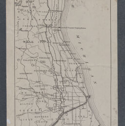
Map of the Des Plaines Basin and Vicinity
From: Goldthwait, J. W. & Illinois State Geological Survey. (1909). Physical features of the Des Plaines Valley (Bulletin 11). Illinois State Geological Survey.
Map showing watershed of Des Plaines River above Joliet, August 1914
From the collection "River Maps" created by the Map Library in the University Library's Digital Collections portal.

Des Plaines River at Joliet September 6, 1939
Entrance of the Illinois and Michigan Canal is visible.
From 1937-1947 Illinois Historical Aerial Photography, in the Illinois Geospatial Clearinghouse.

Des Plaines River at the site of the Grant Creek Cutoff and confluence with the Illinois and Kankakee Rivers, September 6, 1939
From 1937-1947 Illinois Historical Aerial Photography, in the Illinois Geospatial Clearinghouse
Select documents, in chronological order
-
Advance notes of the sanitary investigations of the Illinois river and its tributaries, with special reference to the effect of the sewage of Chicago on the DesPlaines and Illinois rivers prior to the opening of the Chicago Drainage Canal byPublication Date: 1900With special reference to the effect of sewage of Chicago on the Des Plaines and Illinois Rivers prior to and after the opening of the Chicago Drainage Canal.
-
Physical Features of the Des Plaines Valley
byPublication Date: 1909ISGS Bulletin no. 11
Describes bedrock, glacial deposits, and physiographic history of the upper and lower portions of the Des Plaines River. -
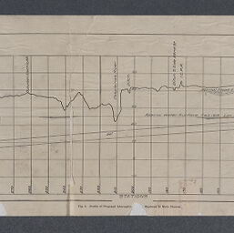 Des Plaines River Investigations profile of preliminary location of intercepting sewer,
by
Publication Date: April 1914Stations and elevation from Maywood to Main Channel
Des Plaines River Investigations profile of preliminary location of intercepting sewer,
by
Publication Date: April 1914Stations and elevation from Maywood to Main Channel -
Des Plaines River : interim plan of flood protection for North Libertyville Estates subdivision byPublication Date: 1962Proposes a system of dikes to protect a subdivision built in the river's flood plain
-
Water quality management basin plan, phase I : Des Plaines River/Lake Michigan byPublication Date: 1976
-
Biologically Significant Illinois Streams : An Evaluation of the Streams of Illinois Based on Aquatic Biodiversity
byPublication Date: 1992The Des Plaines River and Lake Michigan Tributaries are covered on pp. 66-81. -
 Upper Des Plaines River Area Assessment
Publication Date: 1998
Upper Des Plaines River Area Assessment
Publication Date: 1998 -
The Upper Des Plaines River Basin : An Inventory of the Region's Resources
Publication Date: 1998 -
Upper Des Plaines River flood damage reduction study : interim feasability report and environmental impact statement byPublication Date: 1999Evaluates the impact of two prposed levee systems and the expansion of Buffalo Creek Reservoir and Big Bend Lake.
-
 Lower Des Plaines River Area Assessment
Publication Date: 2000
Lower Des Plaines River Area Assessment
Publication Date: 2000 -
The Lower Des Plaines River Basin : An Inventory of the Region's Resources by
Publication Date: 2003 -
 Physical, chemical, and biological responses to urbanization in the Fox and Des Plaines River basins of northeastern Illinois and southeastern Wisconsin
by
Publication Date: 2005USGS Scientific Investigations Report 2005-5218
Physical, chemical, and biological responses to urbanization in the Fox and Des Plaines River basins of northeastern Illinois and southeastern Wisconsin
by
Publication Date: 2005USGS Scientific Investigations Report 2005-5218
Examines impact of urbanization on 45 stream sites in the Fox and Des Plaines River Basins in northeastern Illinois and southeastern Wisconsin using data collected in 2000-2001. Reports chloride and sodium concentrations in water and arsenic, cadmium, chromium, copper, lead, mercury, nickel, and zinc in streambed sediments increased with increasing
percent watershed urban land. Indices representing benthic algal, macroinvertebrate, and fish biological communities declined as urban land cover increased.
National Park Service Flyovers (1979)
-
Des Plaines River (part 1)Flyover video from Joliet to Chicago.
Camera: Barry Rose
Voice: Bob Read
Flight date: October 1979 -
Des Plaines River (part 2)Flyover video from Chicago to Half Day / Lake County Forest Preserve District
Camera: Barry Rose
Voice: Bob Read
Flight date: October 1979